How to Download Resurvey Map in Telangana – A Complete Guide to Access Updated Land Survey Maps Online with mypatta

27 Jul 2026•3 min read•Shreya

blog-cover

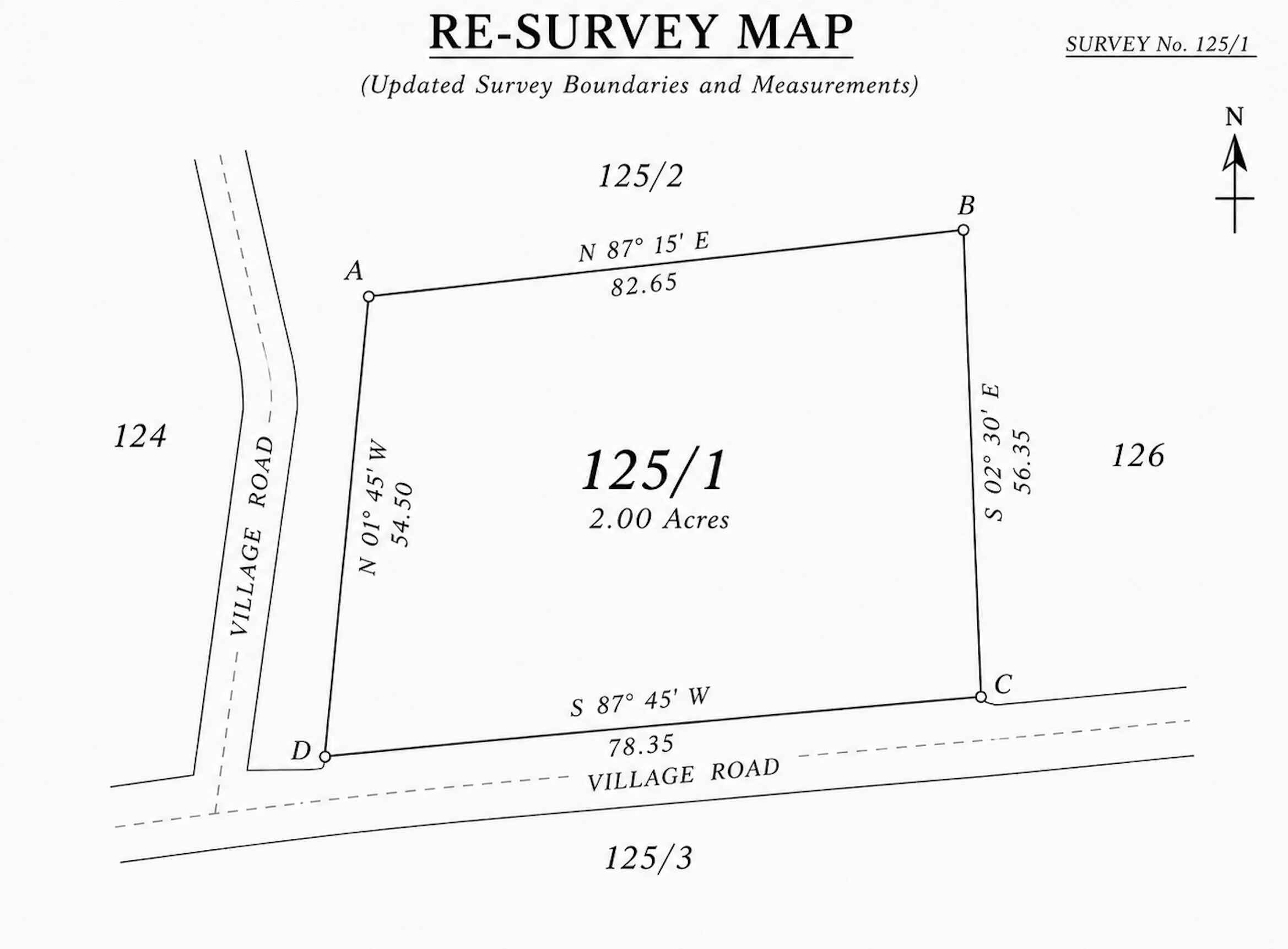
You can easily download Resurvey Map in Telangana through mypatta without visiting multiple government offices. This service helps retrieve updated land survey maps prepared during government resurvey exercises. Resurvey Maps contain revised boundaries, updated measurements, subdivision changes, and corrected survey records, making them useful for land verification, boundary confirmation, and property due diligence.

Key Takeaways

  • Resurvey Maps reflect updated land boundaries and survey measurements.
  • Useful for verifying changes made during government resurvey operations.
  • Helps identify revised survey numbers and subdivision changes.
  • Assists in resolving boundary discrepancies and survey-related issues.
  • Supports property verification and land record validation.
  • mypatta simplifies access to updated cadastral and survey maps online.

Table of Contents

What is Resurvey Map in Telangana?

A Resurvey Map is prepared after a government resurvey exercise and reflects the latest land survey information available for a property. These maps may include revised boundaries, updated land measurements, subdivision modifications, and corrections made to earlier survey records. Since they provide the most recent survey representation of a property, Resurvey Maps are commonly used for land verification and ownership-related matters.

Uses of Resurvey Map

The Resurvey Map Revenue Service can be useful in several property-related situations:

  • Verify Updated Land Boundaries – Confirm current property boundaries reflected in resurvey records.
  • Check Revised Survey Measurements – Review updated land dimensions and measurements.
  • Identify Survey Number Changes – Verify modifications made to survey numbers during resurvey operations.
  • Validate Resurvey Corrections – Review corrections incorporated into updated survey records.
  • Resolve Boundary Discrepancies – Compare revised survey boundaries with earlier records or ground conditions.
  • Review Updated Cadastral Records – Access the latest cadastral mapping information available for a property.

How to download Resurvey Map Through mypatta?

You can quickly request Resurvey Map through mypatta.

Steps to download Resurvey Map Online:

  • Submit your request to initiate record retrieval.

Once available, the Resurvey Map will be shared for your reference, verification, and property-related requirements.

Frequently Asked Questions (FAQs)

1.Why should I obtain a Resurvey Map if I already have a Tippan Map?+

A Resurvey Map reflects updated survey measurements and corrections that may not appear in older survey sketches.

2.Can a Resurvey Map show changes made to survey boundaries?+

Yes. It reflects revisions and updates recorded during official resurvey operations.

3.How do I know if my land was affected during resurvey?+

Comparing old survey records with the Resurvey Map can help identify changes

4.Can a Resurvey Map help resolve measurement differences?+

Yes. It provides the latest officially recognized survey measurements.

5.Why do property buyers review Resurvey Maps?+

They help confirm that the property's current boundaries match official records.

6.Can a Resurvey Map help identify encroachments?+

Yes. Updated boundary information can assist in identifying boundary conflicts.

7.Why do lawyers request Resurvey Maps during land disputes?+

They provide the latest official survey position recognized by revenue and survey authorities

Conclusion

Resurvey Map in Telangana helps property owners, buyers, surveyors, and legal professionals access updated survey maps that reflect the latest land boundaries, measurements, and cadastral information. Whether you need to verify revised survey details, identify subdivision changes, resolve boundary discrepancies, or validate resurvey corrections, Resurvey Maps provide valuable insights into the current status of a property. Through mypatta, you can conveniently request and access Resurvey Maps online, making land verification and survey record retrieval simpler and more efficient.

Similar Blogs

Land Deals Simplified

Instantly download EC, CC, ROR, 7/12, Patta Chitta & Survey Maps. Swiftly resolve property issues with our legal and real-estate experts.

playstore-iconappstore-icon
  • Certified Copy / Nakal
  • EC
  • Property Tax Receipt
  • Signed EC
  • ROR-1B
  • Adangal
  • Certified Adangal
  • Village Maps(FMB/LP)
  • Prohibited Properties
  • Land Disputes
  • Guideline Value
  • Manual CC
  • Manual EC
  • RH Copy
  • Diglot
  • Translate Document
  • Certified Copy / Sale Deed
  • EC
  • Signed EC / Certified EC
  • Village Map
  • Bhoomi RTC / Pahani
  • Signed Bhoomi RTC / Pahani
  • Survey Documents
  • Akarband
  • BBMP eKhata
  • BBMP Record
  • Mutation Record
  • E-Swathu Form 11-B
  • Khata Extract
  • Survey Sketch
  • Certified Copy / Nakal
  • EC
  • Signed EC
  • Patta Chitta
  • FMB Sketch
  • TSLR Extract
  • Village Map
  • A-Register Extract
  • TSLR Sketch
  • Certified Copy / Nakal
  • EC
  • Certified EC
  • Manual EC
  • Land Details
  • ROR-1B
  • Pattadar Passbook
  • Manual CC
  • Translate Document
  • Hydra Map FTL
  • Hydra Map Cadastral
  • FTL Survey Numbers
  • HMDA Land Use Map
  • Property Tax Receipt
  • RERA Certificate
  • Prohibited Properties
  • Title Deed
  • (7/12) Satbara
  • e-Ferfar
  • 8A Extract
  • Property Old Records
  • Bhunaksha
  • Property Card
  • ROR
  • Certified Copy
  • Property Card
  • Certified Copy
  • EC
  • FMB Sketch
  • Document Details
  • Certified Copy / Nakal
  • EC
  • Property Tax Receipt
  • Signed EC
  • ROR-1B
  • Adangal
  • Certified Adangal
  • Village Maps(FMB/LP)
  • Prohibited Properties
  • Land Disputes
  • Guideline Value
  • Manual CC
  • Manual EC
  • RH Copy
  • Diglot
  • Translate Document
  • Certified Copy / Sale Deed
  • EC
  • Signed EC / Certified EC
  • Village Map
  • Bhoomi RTC / Pahani
  • Signed Bhoomi RTC / Pahani
  • Survey Documents
  • Akarband
  • BBMP eKhata
  • BBMP Record
  • Mutation Record
  • E-Swathu Form 11-B
  • Khata Extract
  • Survey Sketch
  • Certified Copy / Nakal
  • EC
  • Signed EC
  • Patta Chitta
  • FMB Sketch
  • TSLR Extract
  • Village Map
  • A-Register Extract
  • TSLR Sketch
  • Certified Copy / Nakal
  • EC
  • Certified EC
  • Manual EC
  • Land Details
  • ROR-1B
  • Pattadar Passbook
  • Manual CC
  • Translate Document
  • Hydra Map FTL
  • Hydra Map Cadastral
  • FTL Survey Numbers
  • HMDA Land Use Map
  • Property Tax Receipt
  • RERA Certificate
  • Prohibited Properties
  • Title Deed
  • (7/12) Satbara
  • e-Ferfar
  • 8A Extract
  • Property Old Records
  • Bhunaksha
  • Property Card
  • ROR
  • Certified Copy
  • Property Card
  • Certified Copy
  • EC
  • FMB Sketch
  • Document Details