How to download Encumbrance Certificate in Uttar Pradesh
You can get the Khasra Land Records in Uttar Pradesh online easily via mypatta without visiting the Sub-Registrar office.
- Open mypatta and log in or sign up if needed.
- Go to property documents, ensure “Uttar Pradesh” is selected as the state, then tap the “Encumbrance Certificate” icon.
- Enter required information.
- Tap “Search”
- Once the Encumbrance Certificate is available to download, tap “View Document”. You can now save or share or download this document in PDF on your device.
What Is a Khasra Record in Uttar Pradesh?
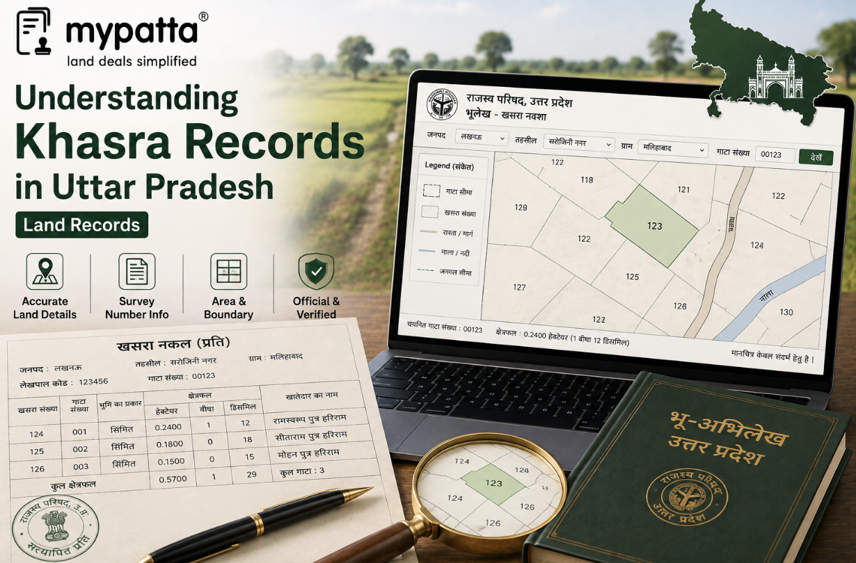
A Khasra is the field book maintained for every revenue village in Uttar Pradesh. It is organised plot by plot and records information connected with individual survey or Gata numbers.
Section 30 of the Uttar Pradesh Revenue Code, 2006 requires the Collector to maintain a village map and field book, identified as the Khasra, for each village. Changes in village boundaries or survey numbers must be recorded in these records, and detected errors or omissions must be corrected. The Code also requires minjumla numbers to be physically divided and the map and Khasra corrected accordingly.
The Khasra is different from a general ownership document because its primary focus is the field parcel. It helps answer questions such as:
- Which Gata number identifies the land?
- What area is recorded against that plot?
- How is the land classified?
- What agricultural or field use appears for the relevant year?
- Does the plot correspond with the village map?
- Have later survey or subdivision changes been incorporated?
A Khasra is usually examined for a particular Fasli year, meaning the agricultural or revenue year to which the field entry relates. The official UP Bhulekh Khasra service displays records according to available Fasli years, showing that a Khasra must be read as a time-specific field record rather than a permanent statement that never changes.
The three principal village land records perform different functions:
- Khasra: Plot-wise field record.
- Khatauni: Landholder and account-wise Record of Rights.
- Revenue map or Shajra: Spatial representation showing the location and boundaries of plots.
The Uttar Pradesh Revenue Code separately requires the maintenance of the Khasra and map under Section 30 and the Khatauni under Section 31.
A Khasra should therefore be used to understand the recorded field position of the land. It does not, by itself, establish a complete legal title or replace the registered deed and Khatauni.
What Information Does a Khasra Contain?
The precise format and available columns may vary according to the Fasli year, village, historical record series and level of digitisation. However, a Khasra generally contains plot-level particulars that help identify and understand the agricultural land.
| Khasra detail | What it generally indicates | What should be checked |
|---|
| District, tehsil and village | Revenue jurisdiction of the record | Whether the correct village and tehsil were selected |
| Fasli year | Agricultural year to which the entry relates | Whether the latest and relevant historical years were examined |
| Gata or Khasra number | Individual land parcel in the village record | Whether it matches the deed, Khatauni and revenue map |
| Recorded area | Area attributed to the individual plot | Whether it matches connected revenue and survey records |
| Land classification | Recorded nature or category of the land | Whether the actual use and claimed use are consistent |
| Cultivation or crop entry | Agricultural use recorded for the relevant period | Whether the land was cultivated, fallow or used differently |
| Cultivator or possession-related entry | Person shown in cultivation or field occupation, where recorded | Whether it agrees with the claimed physical possession |
| Irrigation or field-use particulars | Available information concerning cultivation conditions | Whether it corresponds with the actual field |
| Remarks | Corrections, special entries or field observations | Whether supporting orders or records are required |
Location particulars
A Khasra must be connected with the correct:
- district;
- tehsil;
- village;
- village code, where displayed; and
- Fasli year.
The same Gata number may exist in several villages. A Khasra number without the complete village particulars cannot safely identify the property.
Plot number
The Gata or Khasra number is the principal parcel identifier. Depending on the record and local terminology, the number may appear as a complete plot or as part of a minjumla or subdivided number.
For example, an entry such as “321 min.” may indicate that the record concerns part of a larger numbered plot rather than the entire original Gata. The official UP Bhulekh public reports use plot numbers and areas to connect individual land parcels with the corresponding village revenue record.
Area
The area recorded in the Khasra relates to the individual plot. It must be distinguished from:
- the total area of the khata;
- the combined area of several Gatas;
- the seller’s fractional share;
- the area stated in a registered transaction; and
- the land physically occupied on the ground.
A buyer should not assume that the entire Khasra area belongs exclusively to one person merely because that person appears in the Khatauni.
Land classification and use
The Khasra may help show whether the land is recorded as cultivated agricultural land, fallow, uncultivated or under another field or revenue category.
The exact terminology can differ between records. Any abbreviation, numerical category or local description should be read with the applicable revenue classification and connected Khatauni remarks.
How to Read the Khasra Number, Area and Land Classification
A Khasra should be read in a fixed sequence so that a genuine record for the wrong parcel is not mistaken for the property under review.
Confirm the village and year
First confirm the district, tehsil, village and Fasli year.
A current Khasra may differ from an older record because of:
- subdivision;
- consolidation;
- correction;
- boundary change;
- acquisition;
- change in land use; or
- revision of the village records.
The official Khasra service displays available records by Fasli year. Therefore, the year appearing on the document is central to understanding whether it reflects the current or historical field position.
Identify the complete Gata number
Check whether the number is:
- a complete Gata;
- part of a minjumla number;
- a subdivided plot;
- an old number replaced during consolidation; or
- a number that has been corrected or renumbered.
The Revenue Code specifically requires physical division of minjumla numbers and corresponding correction of the map and Khasra. This means that a claimed private division should not automatically be treated as an officially recognised parcel unless it has reached the revenue and map records.
The number should match:
- the registered deed;
- current Khatauni;
- mutation order;
- revenue map;
- consolidation records; and
- official boundary or demarcation papers.
Read the area carefully
The area may be displayed in hectares or another revenue format used in the record. Verify the unit before comparing it with the deed.
Differences may arise because:
- the deed covers only part of the Gata;
- the Khatauni shows a fractional share;
- the Khasra records the entire plot area;
- a subdivision has not been incorporated;
- part of the land was acquired;
- a map correction is pending; or
- an earlier record contains an error.
Where the deed and Khasra show materially different areas, the discrepancy should be traced through the mutation, subdivision and measurement records.
Understand the land classification
Land classification describes how the parcel is recorded in the revenue system. It may relate to agricultural use, fallow condition, public purpose, water feature or another recognised category.
A classification must not be interpreted only from its plain-language meaning. It should be checked against:
- the exact entry and applicable abbreviation;
- Khatauni category;
- field-use details;
- Revenue authority orders;
- land-use conversion orders; and
- the current physical condition.
For example, agricultural land being physically used for construction does not automatically mean that its revenue classification has lawfully changed. Uttar Pradesh provides a separate process under Section 80 of the Revenue Code for declarations relating to agricultural and non-agricultural use. The Board of Revenue lists this as a separate online service, distinct from Khasra access.
How Are Cultivation, Crop and Possession Details Recorded?
Because the Khasra is the village field book, it is used to examine the field-level agricultural position for the relevant year. Depending on the format and availability of the record, it may contain entries concerning cultivation, crops, fallow status, use of the field and the person shown in cultivation or occupation.
Cultivation particulars
The record may indicate whether the plot was:
- cultivated;
- left fallow;
- uncultivated;
- used for a non-crop purpose; or
- affected by another field condition.
These particulars can change from one agricultural year to another. A historical Khasra may therefore show a different use from the latest entry.
Crop information
Where crop details are recorded, they may identify the crop or agricultural use observed for the relevant season or year.
A crop entry helps understand how the land was being used, but it does not conclusively establish who owns it. A tenant, sharecropper, family member or other cultivator may grow the crop even though the legal tenure holder is someone else.
Possession or cultivator details
Some Khasra formats may contain the name or status of the person shown in cultivation or field possession.
That entry should be compared with:
- the recorded tenure holder in the Khatauni;
- any lease or tenancy arrangement;
- the seller’s claim of possession;
- physical inspection;
- statements of neighbouring landholders; and
- pending possession proceedings.
A difference between the Khatauni holder and the person shown in cultivation is not necessarily an error. It may reflect a lease, family arrangement, joint cultivation or an unauthorised occupation. The reason should be established through supporting documents.
Agricultural-year relevance
Section 30 requires the field book and map to be maintained and relevant changes to be recorded annually or at the prescribed longer interval. This makes it important to check the exact year of the Khasra being relied upon.
The UP Bhulekh Khasra interface similarly allows the available record to be examined by Fasli year. An older Khasra may be useful for historical cultivation or possession, but it should not be represented as the current field position without checking the latest available year.
Limitations of possession entries
A Khasra possession or cultivation entry is evidence of what was recorded during the relevant period. It cannot conclusively decide:
- legal ownership;
- validity of a registered deed;
- permanent tenancy rights;
- a contested adverse-possession claim;
- exact boundary location; or
- entitlement to transfer the land.
Those issues require examination of the applicable title, tenancy, court and survey records.
What Is the Difference Between Khasra and Khatauni?
Khasra and Khatauni are connected land records, but they are organised differently and answer different questions.
Khasra is plot-oriented
The Khasra focuses on an individual Gata or field parcel. It is used to examine:
- plot number;
- area;
- land classification;
- cultivation;
- crop or field use;
- possession-related observations; and
- year-specific field particulars.
Khatauni is holder-oriented
The Khatauni is the Record of Rights maintained for the village. Section 31 of the Revenue Code requires it to contain the names of tenure holders, the survey or plot numbers held by them, their areas, the nature and extent of their interests, their shares and attached liabilities.
It is used to examine:
- khata number;
- tenure holders;
- co-tenure holders;
- recorded shares;
- plots included in the account;
- area of holdings;
- tenure category; and
- mutation or order-related changes.
Practical distinction
The difference can be understood through two questions:
- Khasra: What is recorded about this particular field?
- Khatauni: Which plots and rights are recorded under this landholder’s account?
One Gata appearing in a Khasra may be jointly held by several persons recorded in the Khatauni. Similarly, one Khatauni account may contain several separate Gata numbers, each with its own Khasra entry.
Why both records should be checked
The Khatauni may show that the seller has a one-third share in Gata No. 150. The Khasra may show the total area, classification and cultivation position of Gata No. 150.
Neither record alone necessarily identifies a separately demarcated one-third physical portion. A partition, subdivision, map correction or official demarcation may still be required.
The Revenue Code requires changes affecting the Khatauni, Khasra and map to be recorded and errors to be corrected. These records should therefore broadly correspond, even though they serve different purposes.
How to Access and Verify a UP Khasra Record?
The Uttar Pradesh Board of Revenue provides a separate Bhulekh Khasra service for viewing a Khasra copy and downloading an uncertified copy.
The Board’s current citizen-services page distinguishes between:
- Bhulekh Khatauni;
- Bhulekh Khasra; and
- the revenue village map or Shajra.
It specifically lists the facility to view or download an uncertified Khasra copy.
The record is ordinarily identified using:
- district;
- tehsil;
- village;
- Gata or Khasra number; and
- relevant Fasli year.
The retrieval process should remain brief: select the correct revenue jurisdiction, identify the plot and examine the available year-specific record.
Verify the source and record year
Confirm that the document comes from the official Uttar Pradesh land-record system and clearly displays the relevant village, Gata and Fasli year.
A screenshot without the location and year may be insufficient for reliable verification.
Compare the Gata and area
The number and area should be compared with:
- current Khatauni;
- registered deed;
- mutation order;
- Khasra for adjoining years;
- revenue map; and
- any subdivision or consolidation record.
Check earlier Khasra records
Historical Khasras can help trace earlier land use, cultivation and parcel particulars.
The Uttar Pradesh e-Abhilekh system lists digitised historical Khasra series, including records for Fasli years 1359, 1378, 1379 and 1380, depending on availability.
Older records may be relevant where:
- the present Gata arose from consolidation;
- the land classification changed;
- long-standing cultivation is disputed;
- the current record contains a correction;
- an old deed uses an earlier plot number; or
- historical possession is material.
Check corrections and current status
Section 38 of the Revenue Code permits an application for correction of an error or omission in the map, Khasra or Khatauni. The Tahsildar must conduct the necessary inquiry and process the matter through the prescribed authority.
A Khasra should therefore be checked for:
- corrected Gata number;
- changed area;
- revised land category;
- subdivision;
- map correction;
- pending dispute; and
- inconsistency with the current Khatauni.
Confirm whether an uncertified copy is sufficient
The online Khasra facility describes the publicly downloadable copy as uncertified. It can be used for preliminary checking, but where the record is required for a court, bank, authority or contested transaction, the appropriate certified or officially issued copy should be obtained through the competent Revenue authority.
A Khasra is most reliable when the latest available record, historical entries, Khatauni, revenue map and physical field all identify the same parcel consistently.
Why mypatta?
- Trusted by 7 Lakh+ Customers
- 1 Crore+ Documents Delivered
- mypatta Guarantee: Guaranteed delivery or a 100% refund
- 4.8-Star App Rating
Your money is safe with us: Guaranteed delivery or a 100% amount refund.
Frequently Asked Questions
- 1. Is a Khasra number the same as a khata number?+
No. A Khasra or Gata number identifies an individual field parcel. A khata number identifies the revenue account under which one or more plots and tenure holders are recorded.
- 2. Does a UP Khasra show the owner’s name?+
Its main focus is the plot and field particulars. Ownership and recorded shares should primarily be checked in the Khatauni, together with the mutation and title documents.
- 3. Why does a Khasra mention a Fasli year?+
The Khasra is a year-specific field record. Cultivation, crop, field use and other particulars may change between agricultural years.
- 4. Can a Khasra prove physical possession?+
It may contain cultivation or possession-related information for the relevant year, but it does not conclusively determine current physical possession or legal title.
Shivangi
Real Estate Content Writer
Shivangi is a real estate content writer with 3+ years of experience helping readers understand property documentation, land records, and legal requirements through clear and actionable content.