
Tippan / Tippani cannot ordinarily be used as independent ownership proof in Telangana. It is primarily a field-survey record used to identify the measurements, shape, location and boundaries of a land parcel. It can strengthen an ownership claim by connecting valid title documents with the correct land on the ground, but ownership must be established through documents such as a registered sale deed, gift deed, partition deed, succession records, government grant or court decree.
Can Tippan / Tippani Be Used as Ownership Proof in Telangana?
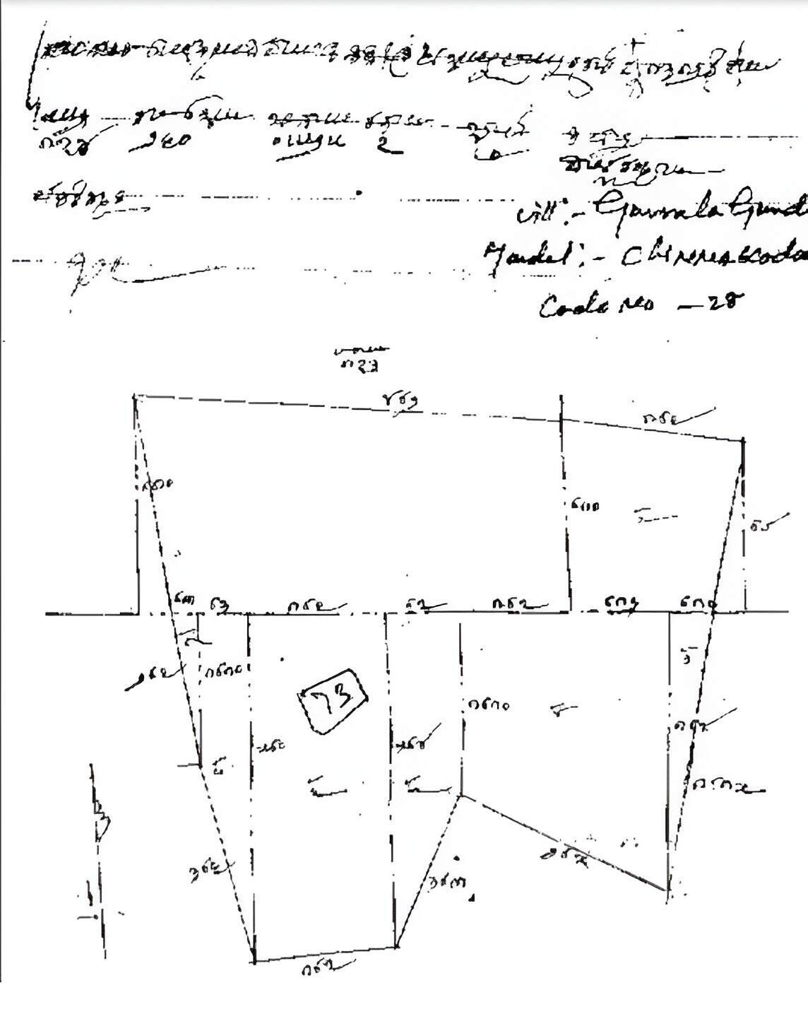
You can get the Tippan Map online easily via mypatta without visiting the Sub-Registrar office.
- Open mypatta and log in or sign up if needed.
- Go to property documents, ensure “Andhra Pradesh” is selected as the state, then tap the “Tippan Map” icon.
- Enter required information.
- Tap “Search”
- Once Tippan Map is available to download, tap “View Document”. You can now save or share or download this document in PDF on your device.
What Does Ownership Proof Mean in a Land Transaction?
Ownership proof means documentary evidence showing how a person legally acquired rights over a particular land parcel and whether those rights continue to remain with that person.
A land document may be important without being a title document. Different records answer different questions:
- A registered sale deed shows how the land was transferred.
- A Mother Deed and link documents trace the earlier ownership chain.
- Revenue records show how the land is entered for administrative purposes.
- An Encumbrance Certificate helps identify registered transactions and charges.
- Survey records help identify the physical land covered by the documents.
A complete ownership claim should establish both title and land identity. Title answers the question, “Who legally owns the property?” Land identity answers, “Which exact parcel is covered by that ownership?”
Tippan / Tippani mainly assists with the second question. It may help locate and measure the land, but it does not normally explain how ownership was acquired.
Where Does Tippan / Tippani Fit in the Ownership Evidence Chain?
Tippan / Tippani fits into the ownership evidence chain as a field-survey and boundary record.
Telangana’s Survey and Land Records Department maintains records such as Tippans, village maps and Sethwars. These records are used for survey administration, land demarcation, subdivisions and resolution of boundary disputes.
A Tippan may show or help explain:
- the survey number of the field;
- the shape of the land parcel;
- field measurements;
- boundary lines;
- adjoining survey parcels;
- subdivisions within a larger survey number; and
- the relationship between the individual field and the village survey layout.
This makes Tippan particularly useful where agricultural land is open, unfenced or part of a larger survey number. It may also be important where the land has been subdivided or where neighbouring owners disagree about the boundary.
However, Tippan does not ordinarily record the complete title history. It does not show every sale, gift, inheritance, mortgage or partition through which ownership may have changed.
It is therefore a supporting record that helps connect title documents with the correct physical parcel.
What Can Tippan / Tippani Legally Establish?
Tippan / Tippani can help establish the survey identity, measurements and boundary framework of land.
It may support the following facts:
- that a particular field forms part of a specified survey number;
- the recorded shape and dimensions of the parcel;
- the location of boundary lines according to survey records;
- the relationship of the land with adjoining fields;
- whether a subdivision was created from a larger survey number;
- whether the extent claimed broadly corresponds with survey measurements; and
- whether the land shown physically is connected with the survey number mentioned in the title deed.
For example, a registered sale deed may state that the purchaser acquired one acre in a specified survey number. The Tippan, subdivision record and official demarcation may help identify where that one acre lies within the larger survey field.
Tippan may also be useful in boundary disputes. If adjoining owners disagree about where one field ends and another begins, the survey department may examine the Tippan along with village maps, survey marks and other records before carrying out demarcation.
Its evidentiary value becomes stronger when the survey details match:
- the registered deed;
- Sethwar and village map;
- current ROR and mutation records;
- official subdivision proceedings;
- land parcel maps; and
- the boundaries found during physical survey.
Tippan therefore helps establish the identity of the property over which ownership is claimed. It does not independently establish the source of ownership.
What Can Tippan / Tippani Not Establish?
Tippan / Tippani cannot establish that the person relying on it has a complete, valid and marketable title.
By itself, it cannot prove:
- how the person acquired ownership;
- whether the seller had a valid title;
- whether the land was legally sold, gifted or inherited;
- whether all co-owners or legal heirs transferred their shares;
- whether a mortgage or registered charge affects the land;
- whether the land was later transferred to another person;
- whether the property is government, assigned or prohibited land;
- whether a court dispute affects ownership; or
- whether the person in possession has a legal right to remain there.
A Tippan may correctly identify a survey parcel even where ownership of that parcel is disputed. Similarly, several persons may claim rights over the same field while agreeing about its physical location.
The record also cannot cure a defective title deed. If a person who did not own the land executed a sale deed, matching Tippan measurements would not make that transfer valid.
Tippan may also require interpretation with other survey records. An old field sketch may not reflect later acquisition, subdivision, road widening, alienation or correction unless the corresponding records were updated.
For this reason, Tippan should not be read in isolation. The certified copy, date, connected survey records and later changes should all be examined.
When Can Tippan / Tippani Strengthen an Ownership Claim?
Tippan / Tippani can substantially strengthen an ownership claim when valid title documents exist but the identity, measurement or boundaries of the land require confirmation.
Its value is stronger when:
- the survey number matches the registered title deed;
- the dimensions correspond with the extent claimed;
- subdivisions are supported by official proceedings;
- adjoining survey numbers match the village map;
- Sethwar and current land records refer to the same parcel;
- official demarcation supports the claimed boundaries;
- physical possession corresponds with the survey record; and
- there is no conflicting title deed or government claim.
For example, a buyer has a registered sale deed for a specific subdivision within a survey number. The seller’s title is supported by link documents, the current ROR reflects the same subdivision, and the Tippan and official survey identify its exact boundaries. In such a case, Tippan strengthens the claim by confirming that the title documents relate to the land occupied on the ground.
The position is weaker where a person relies only on a Tippan and cannot produce any deed, grant, partition document or succession record. The Tippan may identify the field, but it does not explain why that person owns it.
Which Documents Carry Greater Weight Than Tippan / Tippani?
The documents below generally carry greater or more direct weight when the main issue is ownership:
| Document | Role in Ownership Verification |
|---|---|
| Registered Sale Deed | Records the transaction through which property rights were transferred |
| Mother Deed and Link Documents | Trace ownership from earlier holders to the present claimant |
| Gift, Partition or Release Deed | Shows transfer, division or relinquishment of rights |
| Succession and Inheritance Documents | Explain how land passed after an owner’s death |
| Government Grant or Valid Patta | May establish the original source and nature of land rights |
| Court Decree or Order | May declare, divide or determine ownership rights |
| Current ROR and Mutation Records | Support the present revenue-record position |
| Encumbrance Certificate | Helps identify registered transfers, mortgages and charges |
| Sethwar, Village Map and Subdivision Records | Support survey identity and changes in the field |
| Prohibited-Property Records | Help determine whether the land can legally be transferred |
These documents perform different functions. A registered deed may establish transfer, while Tippan helps identify the land covered by that transfer. Revenue records support the current administrative entry, while the Encumbrance Certificate helps disclose registered dealings.
The strongest ownership claim arises when title documents, revenue records, survey records and physical boundaries consistently relate to the same owner and parcel.
FAQs
- 1. Can Tippan / Tippani alone prove ownership in Telangana?
No. Tippan / Tippani is primarily a survey and boundary record. Ownership should be established through registered title deeds, valid grants, succession documents or other recognised title records.
- 2. What legal value does Tippan / Tippani have?
It can support the identification, dimensions, shape and boundaries of a land parcel and may assist in survey demarcation or boundary disputes.
- 3. Is Tippan the same as a registered sale deed?
No. A registered sale deed records the transfer of property rights, while Tippan identifies the field and its survey measurements.
- 4. What if the Tippan measurements do not match the sale deed?
The discrepancy should be checked through subdivision records, Sethwar, village map, current ROR, official survey and correction proceedings before relying on the documents.
- 5. Which documents should be checked with Tippan / Tippani?
Check the registered sale deed, Mother Deed, link documents, Sethwar, village map, current ROR, mutation records, Encumbrance Certificate, subdivision records and prohibited-property status.









