What is a TSLR Sketch?
A TSLR Sketch, or Town Survey Land Register Sketch, is a graphical representation of a land plot as recorded in the urban land survey records maintained by the Tamil Nadu Revenue Department. It depicts the boundaries, measurements, and location of a property within a particular town survey number or subdivision.
What is the Purpose of a TSLR Sketch?
The TSLR Sketch serves several important purposes:
- Visual representation of land plots for legal, planning, and civic purposes.
- Verification of Boundaries before property transactions, construction, or land development
- Support for Building Plan Approvals from municipal or planning authorities.
- In case of land disputes or boundary issues, the sketch can serve as a visual reference to help resolve the conflict.
- Linking to Legal Records such as the TSLR extract, patta, or sale deed.
- It is accepted as supporting evidence in civil disputes.
- Municipalities and planning bodies require it for building permit approvals.
- It helps prevent encroachments and boundary disputes.
- Applying for building plan sanction or approval.
- Selling or buying urban property.
- Fixing boundaries during fencing or construction.
- Filing a case involving land encroachment or boundary dispute.
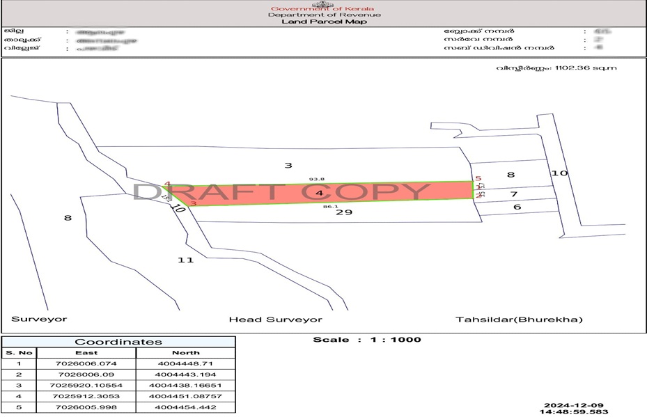
What Information does a TSLR Sketch Contain?
A TSLR Sketch includes the following key components:
- Survey Number and Subdivision Number: Unique ID’s of the land plot.
- Land Area: Size of land plot is recorded(e.g: Length, Breadth and total extent of the property)
- Boundary Details: Representation of adjacent properties or landmarks.
- Plot Orientation: Direction (north, south, etc.) and geographical position.
- Zone Information: Ward number, block, or zone ids
The sketch may also include color codes or labels to identify government lands, roads, or reserved areas
How is a TSLR Sketch Different from a Field Measurement Sketch?
TSLR sketch: Used for documenting land ownership and survey details, often used in urban planning and property transaction
FMB sketch: Used to record precise land dimensions and boundaries on-site and to ensure accuracy in construction and provide a reference for builders and architects
How to download TSLR Sketch Online?
You can get the TSLR Sketch easily through mypatta —without visiting the Sub-Registrar’s office.
Steps to Download Certified Copy Online:
- Open mypatta and log in or sign up if needed.
- Go to property documents, ensure “Tamil Nadu” is selected as the state, then tap the “TSLR Sketch” icon.
- Enter District, Taluka, Town, Ward number, Block Number, Town Survey Number and Subdivision number
- Tap “ Get TSLR Sketch”
- Once TSLR Sketch is available to download, tap “View Document”. You can now save or share or download this document in PDF on your device.
Frequently Asked Questions(FAQs)
1.How is the TSLR Sketch different from a FMB Sketch?
TSLR Sketches are used for urban lands, while FMB Sketches are for rural properties.
2.Is a TSLR Sketch mandatory for property registration?
While not always mandatory, it is highly recommended for verifying land details before transactions.
3.Can I use a TSLR Sketch for building approvals?
Yes, municipal authorities may require it for approving construction plans.
4.What is the validity of a TSLR Sketch?
A TSLR Sketch remains valid unless there are changes in land boundaries due to subdivision, sale, or government acquisition.
5.Can a TSLR Sketch be used as proof of ownership?
No, while it helps verify land details, ownership proof requires a registered sale deed and Patta which you can get on your mypatta .
Key Takeaway
- The TSLR Sketch is an essential urban land record showing clear property boundaries and location details in Tamil Nadu.
- It is crucial for construction, property purchase, and resolving boundary disputes.
- An accurate TSLR Sketch helps prevent conflicts and ensures legal clarity.
- It saves time during planning, verification, and official approvals.
Other Blog Links
1.https://mypatta.in/blog/understanding-tslr-extract-in-tamil-nadu-a-comprehensive-guide/
2.https://mypatta.in/blog/understanding-a-register-extract-in-tamil-nadu-a-vital-land-document
3.https://mypatta.in/blog/certified-copy-nakal-in-tamil-nadu-how-to-get-it-online-its-purpose-faqs/
8.https://mypatta.in/blog/patta-chitta-of-tamil-nadu-how-to-get-it-online-its-purpose-faqs/