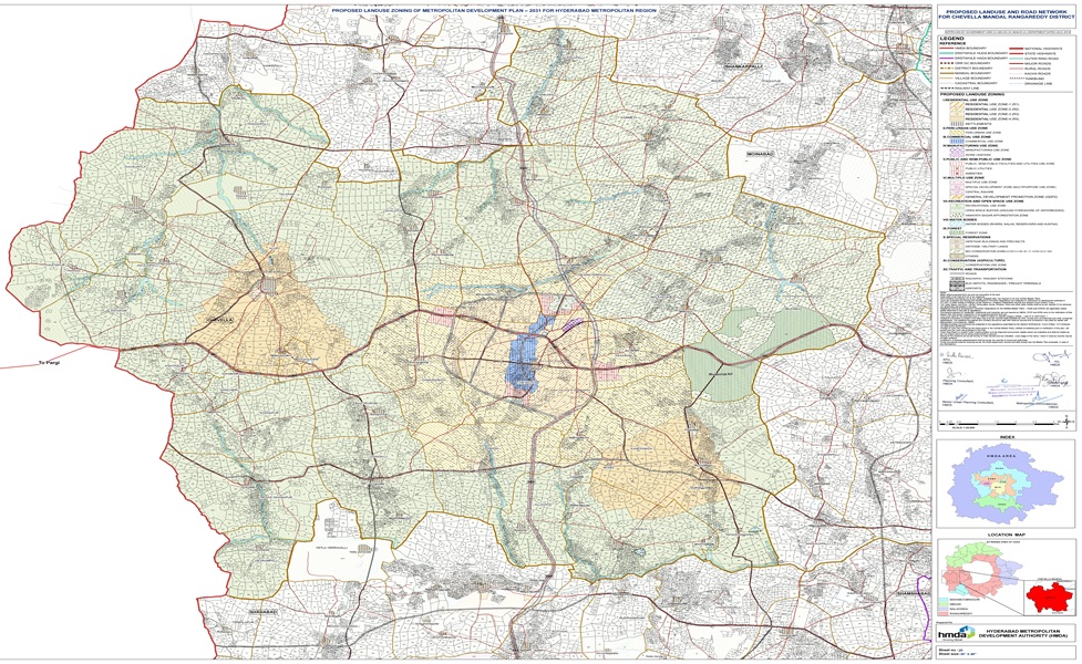
HMDA Land Use defines zoning categories set by the Hyderabad Metropolitan Development Authority, specifying whether land can be used for residential, commercial, or other purposes. It ensures organized urban planning and prevents unauthorized land use.
How to Download Telangana HMDA Land Use Map Quickly Online
- Open mypatta and log in or sign up if needed.
- Select State as Telangana
- Enter required information
- Once the HMDA Land Use Map is made available,you can download, save, or share it.
Through mypatta, you can get an HMDA Land Use Map quickly online without any worries.
How to read & understand Telangana HMDA Land Use Map
Telangana HMDA Land Use Map contains important information which can help in Property Purchase Decision, Building Approvals & Permissions, Legal Compliance, Land Conversion & Zoning Changes, Avoiding Fraudulent Transactions. In HMDA Land Use Map ,you will find –
- Survey Number – Identifies the exact plot or property.
- Land Classification – Residential, commercial, industrial, agricultural, recreational, or institutional.
- Zone Boundaries – Marked as per HMDA planning guidelines.
Who should have Telangana HMDA Land Use Map?
- Property buyers for verifying land zoning
- Builders for planning construction projects
- Developers for layout and project approvals
Why you should download Telangana HMDA Land Use Map through mypatta?
- 🧑🤝🧑 Trusted by 3 Lakh+ customers
- 📥 50 Lakh+ Documents delivered
- 🛡️ mypatta Guarantee – Your money is safe with us – guaranteed delivery or 100% amount refund.
Frequently Asked Questions (FAQs)
1. Is HMDA approval mandatory for building a house in Hyderabad?
If your land falls under HMDA limits, you must get HMDA approval for building plans to avoid legal issues and ensure compliance with zoning rules.
2. Can I build in a green zone under HMDA?
No. Construction in green/recreational zones or buffer areas is typically prohibited and may result in demolition or fines.
3. How do I convert land use in HMDA?
Apply for land use conversion through HMDA with supporting documents and justification. Approval is mandatory before any construction.
4.How often does HMDA update its Land Use Master Plan?
HMDA updates the Master Plan periodically to accommodate urban expansion and development needs.
5. Can commercial activity be done in residential zones under HMDA?
Only limited or mixed-use commercial activities are allowed in residential zones. For full commercial usage, your plot must be zoned as commercial in HMDA map.
Key Takeaway
- The HMDA Land Use Map in Telangana helps you check land classification and its approved purpose.
- It is essential before buying or developing land in Hyderabad and surrounding HMDA limits.
- Verifying HMDA land classification helps you avoid costly mistakes and legal issues.
- Always check the map before you invest, construct, or apply for approvals.
Need help? Contact us on – +91 9177458818