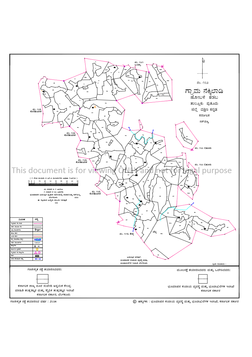
A Village Map in Karnataka is an official land record that shows detailed boundaries of survey numbers, roads, water bodies, and landmarks within a village. It helps property owners and buyers verify land location, access routes, and ownership details .
How to Download Karnataka Village Map Quickly Online
- Open mypatta and log in or sign up if needed.
- Select State as Karnataka.
- Provide District, Taluka,Hobli/Town and Village
- Once the Village Map is instantly made available, you can download, save, or share it .
Through mypatta,you can get Village Map quickly without any worries.
How to read & understand Karnataka Village Map?
Karnataka Village Map contains important information which can help in Land Ownership Verification, Buy or Sell Property, Apply for Loans or Mortgages, Legal Disputes/Litigations, Agricultural Planning .
In Village Map you will find –
- Village Name and Survey Number – Identifies location and land parcel
- Map Scale and Measurement Units – Shows ratio and land dimensions
- Roads, Water Bodies, and Public Landmarks – Key physical and reference features
- Land Use and Category (Agricultural/Residential/Commercial) – Purpose or zoning of land
- Boundaries and Sub-Division Numbers – Defines property limits and sections
Who should have Karnataka Village Map?
- Landowners for verifying property boundaries and survey details
- Buyers for checking land location and nearby landmarks
- Or anyone like farmers who need it for land verification or legal reference
Why you should download Karnataka Village Map through mypatta?
- 🧑🤝🧑 Trusted by 5 Lakh+ customers
- 📥 50 Lakh+ Documents delivered
- 🛡️ mypatta Guarantee – Your money is safe with us – guaranteed delivery or 100% amount refund.
Frequently Asked Questions (FAQs)
1.Can I use a Village Map for property registration?
While a Village Map provides essential geographical details, it is not a substitute for property registration documents but can be used as supporting evidence.
2.Is a Village Map necessary for agricultural loans?
Yes, a Village Map can be used to verify agricultural land details, which may be required for loan applications.
3.Are Village Maps updated regularly?
Yes, Village Maps are updated periodically by SSLR (Survey Settlement and Land Records) department to reflect changes in land usage, ownership, or village infrastructure
4.What should I do if there are discrepancies in my Village Map?
If there are discrepancies, you should report them to the local Revenue Office or Panchayat Office for rectification.
5.Is the Village Map the same as the RTC (Pahani)?
No. The Village Map shows the layout and boundaries of land, while the RTC (Pahani) shows the ownership and cultivation details of the land.
Key Takeaway
- Village maps in Karnataka are essential for landowners, buyers, farmers, and legal experts to verify land boundaries and details.
- Accessing these maps helps ensure accurate property verification and prevents disputes.
- With mypatta, you can get your village map online quickly and conveniently.
- No need to visit government offices—view or download your map digitally from anywhere.
Need help? Contact us on – +91 9177458818