Definition
A Village Map in Tamil Nadu is an official land survey document that provides a visual representation of land parcels, survey numbers, and plot boundaries within a specific village jurisdiction. Maintained by the Survey and Land Records Department, the map helps property owners, buyers, and government authorities verify land location, extent, and subdivision details
How to View Village Map of Tamil Nadu Online?
You can now access the Tamil Nadu Village Map digitally via mypatta— no more standing in queues.
- Open mypatta and log in or sign up if needed.
- Ensure “Tamil Nadu” is selected as the state, then tap the “Village Map” icon.
- Enter your district, taluk, village, and survey number
- Tap “Get Village Map” and pay fees.
- Once Village Map is available to download, tap “View Document”. You can now save or share or download this document in PDF on your device.
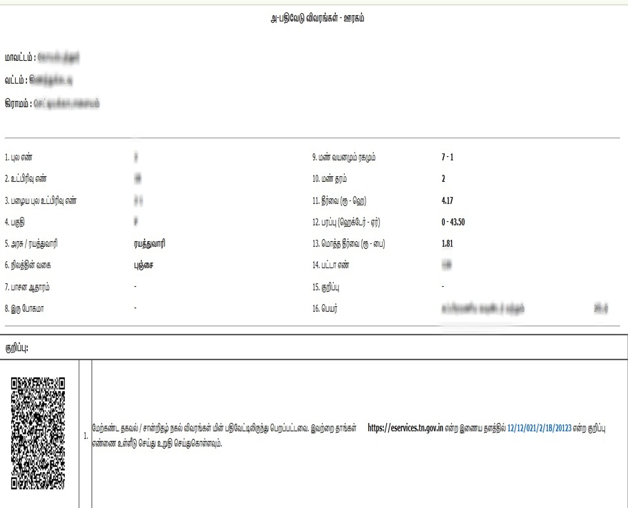
Information Contained in a Village Map in Tamil Nadu
A typical Village Map in Tamil Nadu includes:
- Survey Number & Sub-division Number – Unique identifiers for land plots.
- Land Parcels – Exact demarcation of individual properties.
- Boundaries & Extent – Outlines the size and shape of each land parcel.
- Neighboring Plots – Helps in identifying adjacent property owners.
Role and Purpose of Village Map in Tamil Nadu
The village land records map is critical for multiple land-related activities. Its importance and uses include:
- Property Ownership Verification – Confirms that the land parcel matches the registered survey number and boundaries.
- Dispute Resolution – Used in court cases or local disputes to establish legal property boundaries and prevent encroachment.
- Agricultural Planning & Loan Approvals – Farmers use the map to apply for crop loans, government subsidies, and irrigation projects.
- Government Land Use & Development – Supports village planning, road layouts, infrastructure development, and land acquisition.
- Fraud Prevention – Buyers can cross-check the exact land parcel before registration to avoid fraudulent transactions.
- Patta & Chitta Updates – Helps in applying for Patta transfers, updating land records, or applying for an Encumbrance Certificate (EC).
- Urban Planning – Useful for identifying zoning classifications and future expansion of towns or villages.
- Environmental Management – Helps in conserving water bodies and identifying encroachments on common lands.
- Inheritance & Partition – Families use it for dividing ancestral properties accurately.
- Industrial Development – Investors use it to identify suitable land parcels for factories, warehouses, or commercial projects.
Important Tips and Considerations
- Always cross-verify the survey number online before downloading the map to ensure accuracy.
- Check for latest updates to avoid disputes caused by outdated boundary lines.
- Keep copies for future property transactions or legal requirements.
💡 Expert Tip: A Village Map alone is not legal proof of ownership. Always use it along with Patta/Chitta, FMB Sketch, and Encumbrance Certificate (EC) for complete property verification.
Frequently Asked Questions (FAQs)
1.What is the difference between a Village Map and a Field Measurement Book (FMB) Sketch?
A Village Map provides an overview of the entire village, showing roads, boundaries, and survey numbers. In contrast, an FMB Sketch focuses on the detailed measurements and layout of individual land parcels.
2.Is a Village Map mandatory for property registration?
While not always mandatory, a Village Map can be crucial in verifying land boundaries and survey numbers during property registration.
3.Why is a Village Map important for property buyers?
A Village Map helps property buyers verify the exact location, boundaries, and surrounding landmarks of a property, ensuring clarity before proceeding with transactions.
4.What should I do if my land is not shown in the Village Map?
If your land is missing, you should contact the local Revenue or Survey office and file a request for updating the records.”
5.Can I use a Village Map for loan applications?
Yes, banks may request a Village Map as part of the documentation for verifying land details during agricultural or property loan processing.
Key Takeaways
- The Village Map is not proof of ownership but is crucial for land planning and verification.
- It can be easily accessed via mypatta app.
- Helps farmers, landowners, buyers, and officials make better land-related decisions.